
Industry and Opinion
GEM420: What a Router Name, a Cloth Cat and a Nursery Rhyme Taught Me About Language
I was watching Bagpuss with my daughter last week. If you’re not familiar with the 1974 BBC series,…
There is a particular kind of arrogance that settles into modern thinking about data, a quiet assumption that systematic measurement began with Victorian scientists, industrial-era spreadsheets, or satellite telemetry. Joseon-era Korea, which ran from 1392 to 1910, quietly dismantles that assumption.
In the mid-1400s, Korea did not simply invent a rain gauge. It built a standardised national observation network, enforced consistent measurement practices across a geographically dispersed administrative system, and used the results directly for policy. The Cheugugi programme is one of the earliest documented examples of what we would now call state-run environmental data governance: the systematic measurement of rainfall because the harvest, the tax base, and social stability depended on it.
This article is a complete reference for the Appleby Institution: what the Cheugugi system was, how it worked, where it was deployed, what survives, what records exist, and where the modern archive now lives. It also examines a question the Cheugugi raises uncomfortably for the present day – what happens when we stop waiting for data and start generating conclusions first.
Joseon Korea was an agricultural state, and rice was not a side dish. It was the backbone of food security, tax revenue, military provisioning, and public order. Famine and civil unrest have a long relationship, and Joseon’s administrators understood that clearly.
Rainfall drives rice yields. Monsoon regions do not fail gently. A bad season could mean drought; two consecutive bad seasons could mean famine. Excessive rainfall brought its own destruction through flooding, waterlogging, and crop disease. The hardest problem for governance was that rainfall is not uniform. One province could be drowning while another cracked. A central authority collecting vague field impressions from local officials had no workable basis for tax relief, emergency redistribution, or grain reserve planning.
Before Cheugugi, the most common proxy for rainfall was soil penetration depth: how far down had the rain soaked? The obvious problem is that soil penetration depends on soil type, slope, drainage, prior saturation, and land use. Two regions receiving identical rainfall could look entirely different on the ground. Governing fairly with that kind of information is close to impossible.
Joseon’s answer was practical and direct: measure the rain itself, from above, in a standardised vessel, with consistent technique, before absorption can distort the figure. The result is a number that means the same thing in every province where it is recorded.
The Cheugugi system emerged in two connected steps. Development and early implementation began in 1441, during the reign of King Sejong the Great. Standardisation and national expansion followed in 1442, when the design was formalised and the instrument was distributed through provincial administration.
The distinction between “invented” and “operational at scale” matters enormously. Instruments are invented and then abandoned all the time. Cheugugi succeeded because it was never just a prototype; from a very early stage it was conceived as an institutional system combining a standard instrument, consistent measurement procedures, and a reporting chain back to the capital.
King Sejong’s court was already oriented toward practical science: astronomical instruments, calendar reform, timekeeping, and administrative rationalisation were all active priorities. Cheugugi belongs in that same tradition. Various individuals within the royal court are credited in different sources with the concept and its execution, but the important historical point is that this was a government programme, not a hobbyist invention.
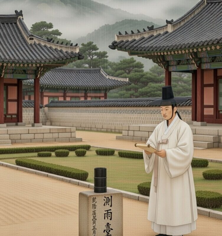
At its core, Cheugugi is a cylindrical container designed to collect falling rain. After rainfall ceased, or at defined observation intervals, an official measured the depth of collected water using a calibrated ruler and entered the result into administrative records.
The name itself is descriptive. “Cheugg” (측) relates to measurement; “u” (우) refers to rain; “gi” (기) denotes instrument. The Cheugugi is, literally, a rain-measuring instrument.
Standard dimensions. Joseon standardised the vessel’s geometry so that measurements would be comparable across the country. Specifications commonly given in modern scholarly reconstructions place the height at approximately 31.9 cm and the diameter at approximately 14.9 cm. Some variation appears across different papers, centuries of manufacture, and surviving examples, which is normal when dealing with a system that ran across several hundred years and multiple manufacturing episodes. The key is not millimetre precision in any single surviving gauge. The key is that a national standard existed and was enforced.
Materials. Early Cheugugi were manufactured in iron. Later examples appear in copper and bronze, and ceramic variants are discussed in some historical secondary sources. Again, the material detail matters less than the principle: a standard vessel produced to consistent specification.
The pedestal: Cheugudae. The gauge was not simply placed on the ground. It sat on a stone pedestal (Cheugudae) which served several functions simultaneously. It reduced contamination from ground splash, improved stability, removed the gauge from direct contact with soil runoff, and created a consistent posture for taking measurements. This is the kind of unglamorous engineering decision that makes data usable. Nothing dramatic, but everything consequential.
The ruler: Jucheok. A standardised gauge requires a standardised measurement tool. Joseon paired the Cheugugi with a standard ruler – the Jucheok or Chucheok – used to measure collected water depth. Measurements were recorded in traditional units using chi, cun, and fun subdivisions, which modern researchers convert to millimetres for contemporary analysis. Standardising both the vessel and the measuring tool is a closed system: neither element can drift independently without compromising the record.
What was recorded. Joseon rainfall observations could include the total depth of collected water as a quantitative figure, the start and end times of the rainfall event, and additional notes for unusual conditions such as storms, floods, or exceptionally heavy falls. The inclusion of event timing is significant. It means the records capture the shape of rainfall events – duration and intensity – not just totals. That level of temporal structure is considerably more sophisticated than most people assume for pre-modern environmental observation.
The Cheugugi system’s larger achievement was not the instrument itself but the national deployment. This is the part most general accounts understate.
Cheugugi units were distributed to provincial offices throughout the country, with local magistrates responsible for measurement, recording, and reporting upward through the administrative hierarchy to the capital. Joseon Korea organised its territory around eight provinces as the primary administrative framework, and Cheugugi deployment is described in that context: a standard instrument at each level of provincial administration, producing comparable data that could be aggregated centrally.
Gauges were installed at official government locations: provincial offices, the courtyards of local government compounds, and magistrate premises. The placement is not incidental. Installing the instrument within government-controlled space meant the state could enforce method, monitor compliance, and maintain the archive. A gauge in a farmer’s field is an anecdote. A gauge in a magistrate’s courtyard is infrastructure.
The officials responsible for measurement were not scientists in the modern sense. They were administrators with a duty to report accurately, in the same way they had duties around tax collection and census counting. The incentive structure was governance accountability, not scientific curiosity, and that may be precisely why the system persisted for as long as it did.
Claims of unbroken nationwide daily records spanning four hundred years should be treated with caution. The Cheugugi system existed for centuries as an institution, but the surviving documentary archive has genuine gaps, and those gaps have a clear cause.
The Japanese invasions of 1592 and 1597 – known in Korean history as the Imjin War – caused massive destruction of administrative infrastructure across the country. Government buildings, their contents, and the officials who maintained them were lost on a scale that left corresponding holes in the archival record. A measurement system is only as durable as the institutions around it.
Despite this, the network was restored. Measurement resumed after the invasions, and the system continued operating in some form through to the late nineteenth and early twentieth century. The restoration is itself significant: Joseon’s administration considered the rainfall record worth rebuilding. That is not a reflex action. It reflects an institutional understanding of why the data mattered.
Cheugugi did not exist in isolation. It was one component of a broader programme of measurement and administrative rationalisation pursued during and after the reign of King Sejong.
Alongside rainfall measurement, Joseon developed the Supyo: a calibrated gauge for measuring river and stream water levels, installed at sites including the Cheonggyecheon stream in Seoul and the Han River. Where Cheugugi captured rainfall input, Supyo captured hydrological response. The combination gave administrators a more complete picture of the water system affecting agriculture and urban flooding than either instrument could provide alone.
Consistent rainfall recording also requires consistent timekeeping. Knowing when rain started and ended depends on having an agreed time reference across the reporting network. Sejong’s court invested in timekeeping instruments and conventions during the same period, which made regularised observation possible at a practical level.
A data culture is never built on a single instrument. It requires standards, time discipline, reporting chains, archive systems, and incentives for compliance. Joseon assembled all of those components, and Cheugugi was the most famous product of that assembly.
The earliest 1440s gauges do not survive as a cohesive collection. What museum visitors and researchers can encounter today tends to be later-period examples, surviving stone pedestals, and documentary records.
The most widely referenced surviving physical rain gauge is a later official example manufactured in 1837, associated with the provincial office at Gongju in the Chungcheong region. It is cited in the literature as Korea’s oldest remaining physical rain gauge example and has received formal national heritage designation. Because heritage classification systems and numbering schemes are subject to revision as agencies update their frameworks, the safe description for a permanent reference is: a surviving official rain gauge manufactured in 1837 to the standardised Joseon dimensions originally established in the 1440s, historically installed at a provincial government site in Gongju, and formally designated as a nationally significant heritage object in Korea.
Multiple Cheugudae stone pedestals are also known to survive. These matter beyond their physical presence: a surviving pedestal confirms institutional placement even when the gauge it once held is gone. Related historic instruments and observation structures are preserved across palace collections, national museums, and heritage sites, reflecting how deeply measurement was embedded in Joseon governance.
For research purposes, it helps to distinguish three distinct layers of the archive.
The primary Joseon record sources. Modern climate researchers reconstructing historical rainfall data draw primarily on three major documentary collections. The Annals of the Joseon Dynasty (Sillok) is a massive dynastic chronicle that, while not a weather log as such, contains the institutional and event records from which rainfall-related policy decisions and anomalies can be extracted. The Seungjeongwon Ilgi – the Diaries of the Royal Secretariat – are daily administrative records that include weather observations as a routine entry. The Ilseongnok, daily records of kings’ lives and state affairs, provides further diary-format daily documentation including rainfall and weather conditions. All three collections have received international recognition as major heritage documentary series, and all three function as structured daily governance records rather than informal observations.
Modern digitisation. Korea has digitised substantial portions of these historical documents, making them searchable and parseable at scale. Without digitisation, extracting climate data would require individual researchers to work through thousands of handwritten pages manually. Digitisation is what makes large-scale reconstruction feasible.
Reconstructed datasets. The flagship product of this research for practical use is the reconstructed daily precipitation series for Seoul covering 1778 to 1907. Built by parsing digitised secretariat and court records and applying cross-checking and quality control methods, it represents the most accessible and scholarly validated entry point into Joseon rainfall data for researchers working in climate history, historical ecology, or related fields.
A serious institutional reference page should be precise rather than promotional. The Cheugugi story is genuinely impressive without embellishment.
It is accurate to say that Korea established one of the earliest state-run standardised rainfall measurement networks in recorded history, that Cheugugi was standardised in design and deployed nationally through provincial administration from 1442, that records include rainfall depth and in many cases event timing, and that a scholarly reconstructed daily precipitation series for Seoul covering 1778 to 1907 is available in the research literature, built from digitised primary administrative documents.
It is not accurate to claim unbroken nationwide daily records spanning four hundred years – war and archival disruption make that untenable. Nor is it accurate to describe the instruments as unimproved by modern science – that kind of tourist-brochure phrasing signals exactly the imprecision that institutional credibility is undermined by.
The actual record is remarkable enough. A government-mandated national measurement network, operational in the fifteenth century, producing quantitative rainfall data used for policy, with a surviving archival chain extending through to the early twentieth century and supporting active modern climate research today. That stands on its own.
Here is the uncomfortable part.
Joseon Korea in the fifteenth century understood something that a significant portion of modern environmental science has quietly walked away from: you measure first, then you conclude. The whole point of the Cheugugi was that the data arrives before the policy decision, not after it. The gauge does not know what answer the harvest minister wants. It measures what fell.
That discipline – measurement first, interpretation second – is no longer guaranteed in the way we handle environmental data today. We have more instruments than any previous civilisation. We have satellites, ocean buoys, atmospheric sensors, and global networks that the Joseon magistrates could not have imagined. And yet a pattern has emerged that would have struck those administrators as deeply strange: we increasingly build the conclusion first and fit the data to it afterwards.
The modern preference in environmental science, particularly in climate research and ecological projection, has drifted toward modelling as the primary output. A model is not a measurement. A model is a set of assumptions encoded in mathematics, run forward to produce a projection. That projection is only as honest as the assumptions that generated it. When the assumptions are chosen to reflect a prior conclusion – when the model is calibrated to produce a specific range of outcomes because those outcomes align with a funding priority, a policy position, or a prevailing consensus – the model is no longer science in any meaningful sense. It is arithmetic dressed as evidence.
This matters in the context of Cheugugi specifically because the historical rainfall record exists. Korea has continuous quantitative precipitation data covering Seoul from 1778 onwards. Joseon rainfall data has been used in peer-reviewed climate research. The record is real, it is digitised, and it is available. Historical data of this quality is rare. It provides an independent check on what regional climate actually did over centuries – not what a model projected it would do, but what was physically measured by people with no stake in the outcome.
Whether that record is used honestly, or selectively, or ignored when it is inconvenient, tells you a great deal about the current state of environmental science.
The trend that should concern us is this: when measured historical data contradicts a modelled projection, the response in mainstream environmental discourse is increasingly to question the historical data rather than the model. Instrumental records get adjusted. Baseline periods get shifted. Anomalies get smoothed. The raw data – the thing closest to what actually happened – gets treated as less reliable than a computer simulation built on contested assumptions. A fifteenth-century Korean magistrate would find that baffling.
We have also developed a habit of treating model outputs as facts in public communication long before they have been validated against observation. A projection becomes a prediction. A prediction becomes a finding. A finding becomes a consensus. A consensus becomes something you are not allowed to question. At no point in that chain did anyone go outside and put a gauge in a courtyard. The Cheugugi approach – measure the actual thing, record it accurately, report it honestly – has been replaced in many quarters by a pipeline that runs from assumption to headline without much stopping in between.
None of this means that environmental change is not real, or that measurement programmes are not worth funding. It means that the quality of reasoning matters, and that the habit of subordinating data to narrative is corrosive regardless of which direction the narrative runs. A measurement that contradicts your model is not a problem to be managed. It is information. That is what the data is for.
Joseon Korea built a national rainfall network because they needed to know what was actually happening in order to govern well. They did not build a model of what rainfall probably did and treat that as equivalent. They measured. They recorded. They used the results even when the results meant difficult decisions.
That approach did not require fifteenth-century technology. It required intellectual honesty. That requirement has not changed.
Cheugugi (측우기). The standardised cylindrical rain gauge used in the Joseon observation system, standardised in 1442.
Cheugudae (측우대). The stone pedestal on which the Cheugugi was mounted, providing stability and reducing ground-level contamination.
Jucheok / Chucheok. The standardised ruler used to measure collected water depth inside the Cheugugi.
Joseon. The Korean dynastic state that ran from 1392 to 1910, during which the Cheugugi system was developed and operated.
Magistrate. The local government official responsible for administration within a district, including oversight of Cheugugi measurement and reporting.
Seungjeongwon Ilgi. Diaries of the Royal Secretariat; daily administrative records that form one of the three primary sources for reconstructing Joseon rainfall data.
Ilseongnok. Daily records of kings’ lives and state affairs; a further primary documentary source for historical weather and rainfall data.
Sillok. The Annals of the Joseon Dynasty; a comprehensive dynastic chronicle containing institutional and event records relevant to weather, floods, and policy responses.
Supyo. A calibrated river and stream water level gauge used alongside the Cheugugi to relate rainfall measurements to hydrological response.
Monsoon variability. The year-to-year and multi-year fluctuation in the timing, intensity, and duration of seasonal monsoon rainfall, which drove much of the practical value of the Cheugugi record for Joseon agricultural and fiscal planning.
Prepared for the Appleby Institution and nickappleby.co.uk. Sources consulted include research published via Scientific Data (Nature Portfolio), PubMed Central, The Conversation, KoreaScience, ArXiv, and Korean heritage documentation. No external hyperlinks are included in this reference version.
I was watching Bagpuss with my daughter last week. If you’re not familiar with the 1974 BBC series,…

Zero Trust: What Networks Can Teach Us About the Most Human Thing There Is In security, zero trust…

What they are, how they work, where they’re deployed, and why they matter to anyone building connected infrastructure.…